- Survey
- Right-of-Way
- GIS
- LiDAR & Aerial Mapping
- High Definition Survey/Laser Scanning
- Blue Sky Evolution
- Plat Mapper
- Route Mapper
- Data Halo
-

Survey
Route Reconnaissance & Selection
Preliminary & Design Survey
As-Built & Construction Survey
SUE Investigations
HCA, Line Class & Obstructions Surveys
Remediation Surveys
Topographic Surveys
Gathering System Layout
Boundary Surveys
ALTA/ACSM Surveys
Existing Asset Surveys
Base Map Generation
LiDAR/Aerial Mapping
Property Exhibit Generation
Certified Plat Development
Well Package Development
HDD Design Drawings
Permit Crossing Drawings
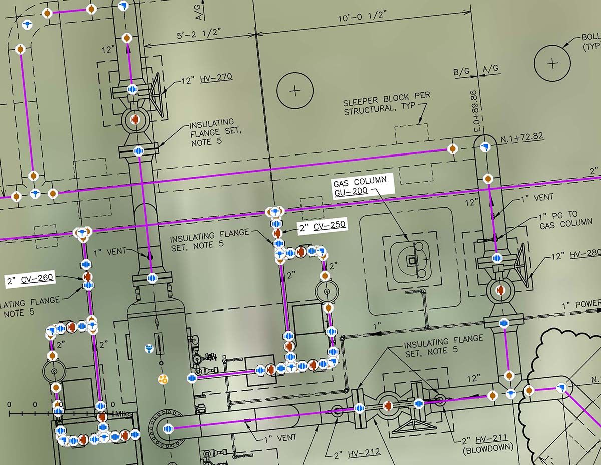
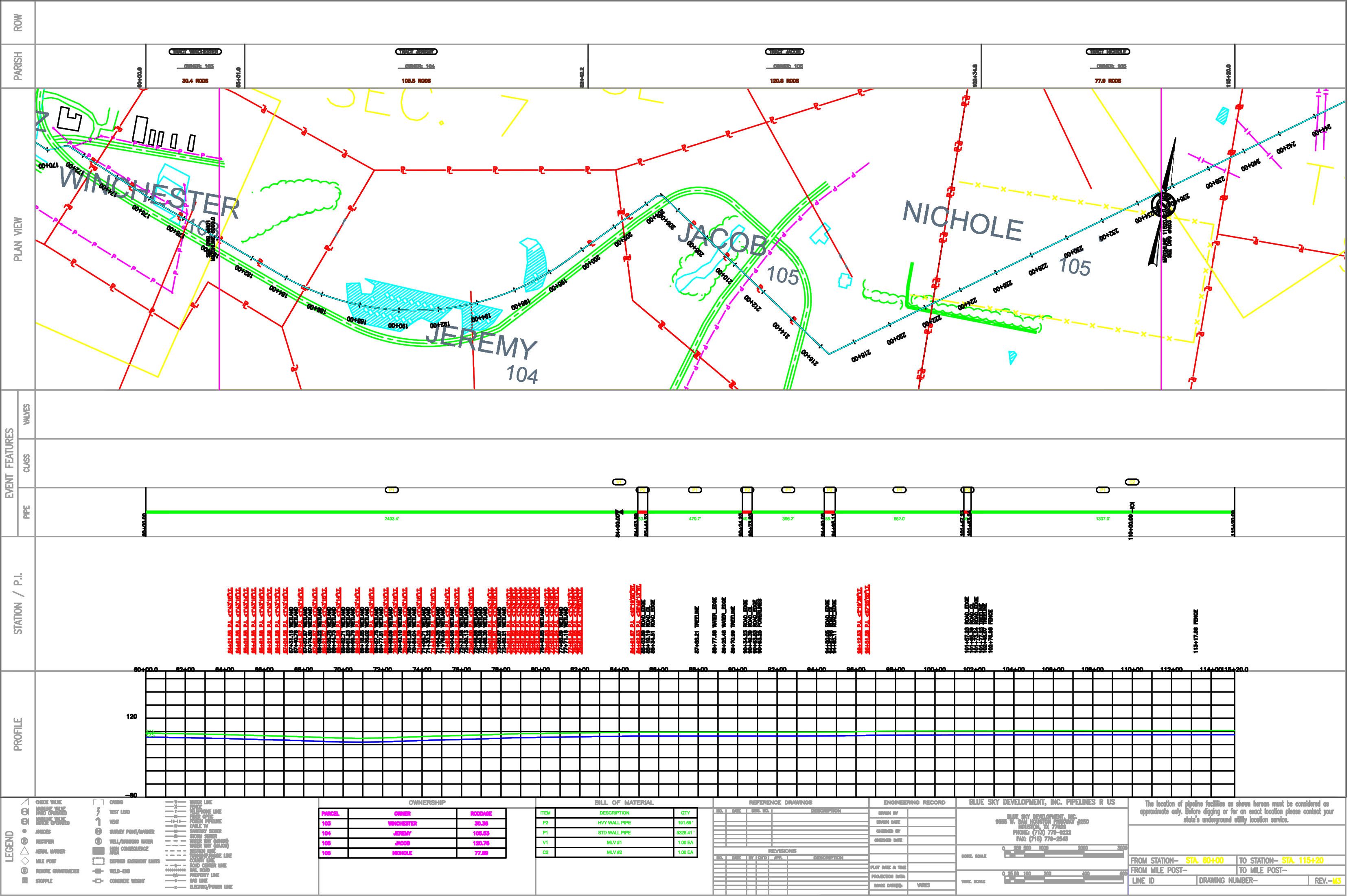
Alignment Sheet Generation -

Right-of-Way
Title Research
Land/ROW Records Management
Land Right Negotiations/Acquisition
Permit Filing/Management
Land Database Management
Surface & Mineral Title Examination
Genealogy Research
Division Order Preparation
Construction Support & Outreach
Compliance & Litigation Support
Due Diligence -
GIS
Web Application Development
Full Company GIS Support
System Integration Consulting
Document Scanning/OCR Extraction
Acquisition and Asset Mapping
Land Records and Database Management
GIS Project Management
Geodatabase Creation/Management
Mobil GIS Applications
Facility Mapping/MAOP Tracking
Property Exhibit Generation
Alignment Sheet Generation
Automated Data Management -
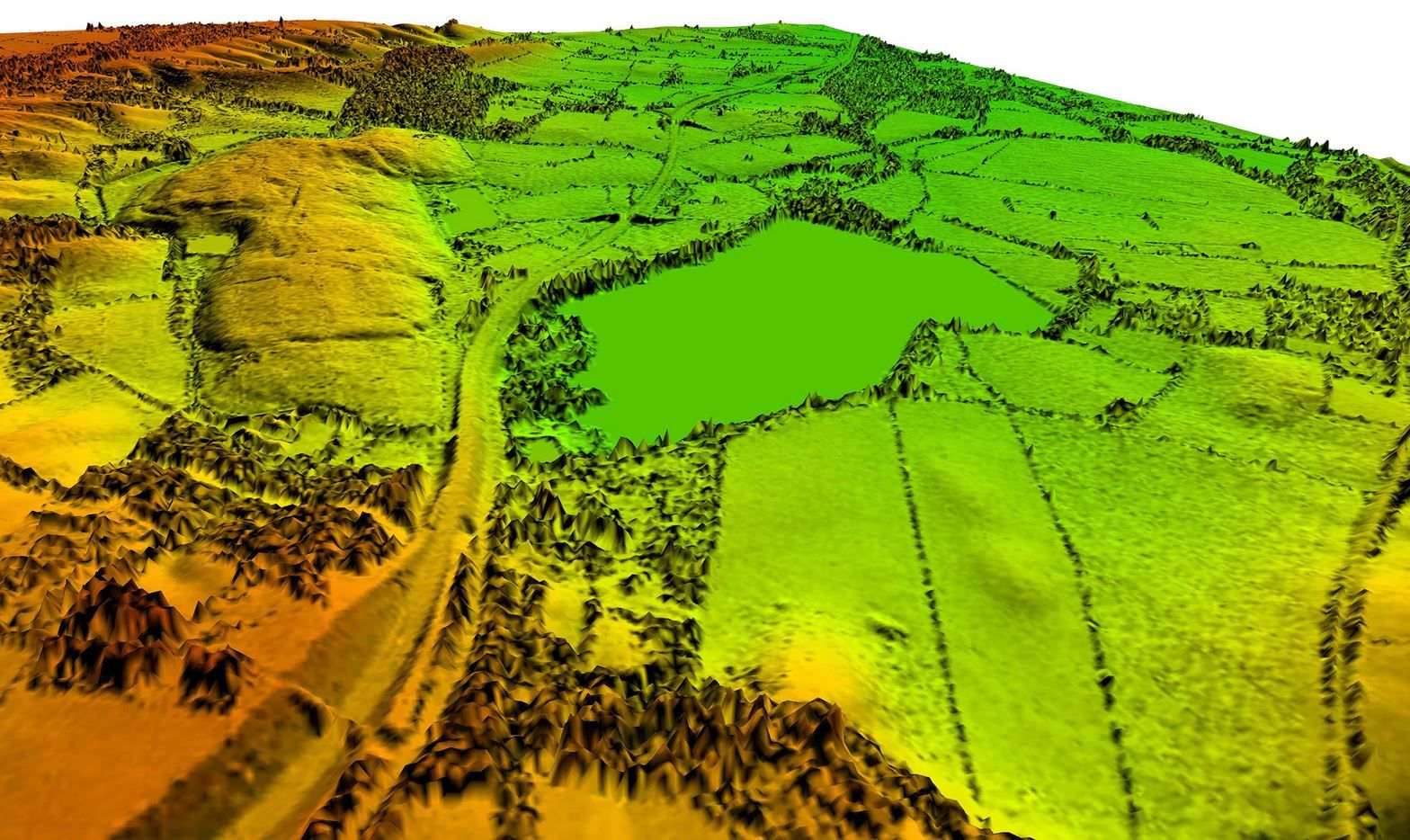
LiDAR & Aerial Mapping
The use of Light Detection and Ranging (LiDAR) cameras mounted on helicopters or fixed wing aircraft has changed the standard in the market when it comes to collecting topographic and geographical design information.
This technology allows for proposed routes to be flown based on the assumed points of intersection with defined areas of coverage to either side of the proposed centerline. From this flight, detailed survey grade Digital Terrain Models are developed in concert with accurate Aerial Orthophotography for the project design team to utilize throughout the engineering and constructability phases of a given project.Encompass LiDAR Technology – Associated equipment
- Airborne LiDAR
Fixed Wing Drone
Rotary Drone
Fixed Wing Plane
- Terrestrial LiDAR
Mobile Mapping
3-D Scanning -
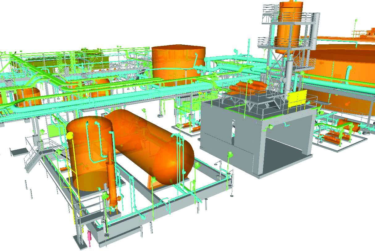
High Definition Survey/Laser Scanning
This type surveying system is a high-speed, high-accuracy laser scanner with a 360° x 270° field of view. The technology can scan any interior/exterior of man-made/natural structures or areas within its field of view and create a complete raw data set in the form of a 3D image made up of millions of points of data, called a "3D point cloud". Every two points of the 3D point cloud provide direct point to point measurements within AutoCAD.
Quick, complete surface geometry is safely and accurately captured with the High-Definition Surveying system. More accurate, complete as-builts for retrofit design projects translate into better retrofit designs and can be derived safer and with a higher level of detail. -
Blue Sky Evolution
Skyline is the most powerful and robust tool for generating alignment sheets. Data driven and built on cutting edge technology, Skyline takes you to clean alignment sheets faster and easier. Skyline automatically populates a project database as you create alignment sheets. The format populated is the industry standard for new construction and can feed into the vast majority of operational data models.
- Easily create a database that can load into other models.
- Manage & maintain the safety of your lines and pipes with the ability to process changes quickly.
- Information on the sheets will always match the data ensuring standardized data.
- Provides adaptable deliverables for multiple workflows.
- Data is loadable into PODS, PODS Spatial, UPDM and APDM
-

Plat Mapper
Plat Mapper automates Plat Exhibits for Survey and Right-of-Way acquisitions. This software can automate 1 to 100's of Plat Exhibits at one time. Plat Mapper saves on time and money with quicker production rates.
- Automates the cutting of Plats into separate Plats (Plats are numbered per the Parcel Tract Id Numbers) Automates the trimming of each Parcel Tract while setting all the viewport scaling in paperspace.
- Automates the calculations for Length, Rods and Acreages for Permanent Easement, Temporary Workspace and Additional Temporary Workspace.
- Automates Bearing and Distance for centerline and property lines.
- Automates the Line Table for bearing and distances.
-
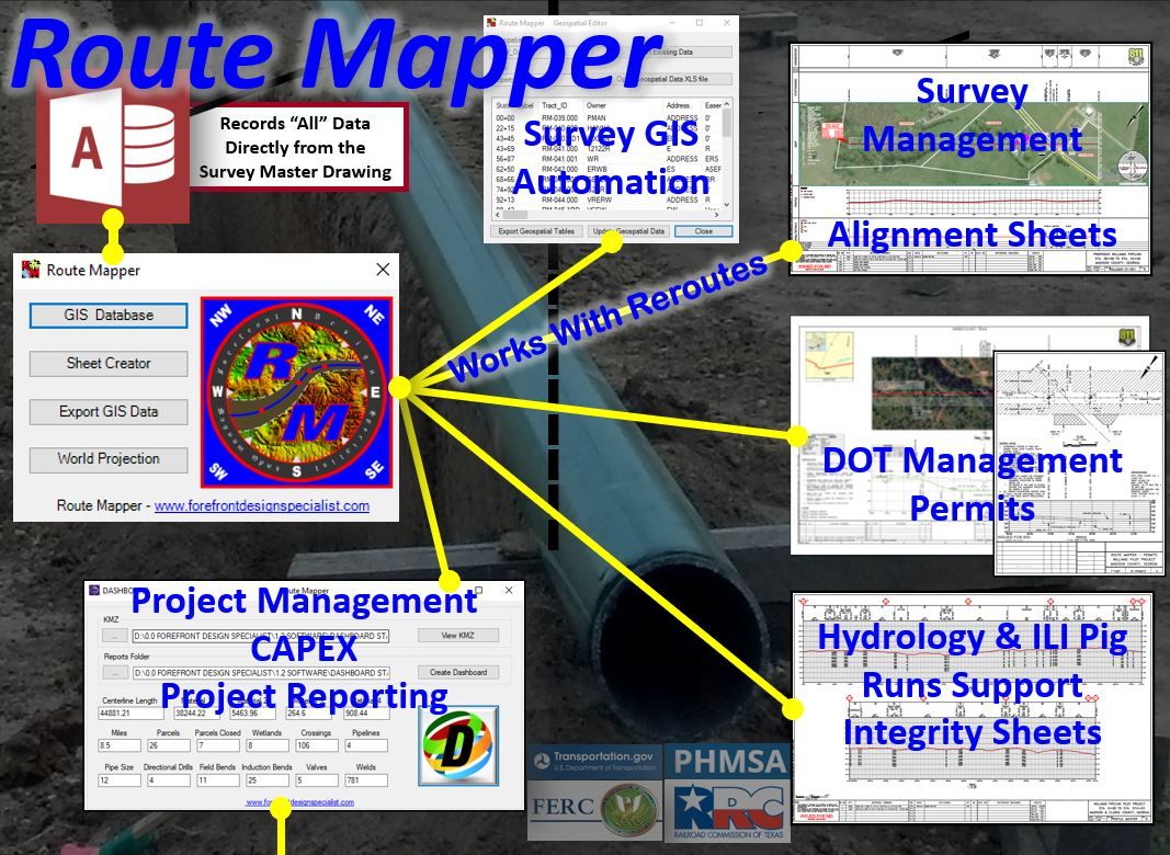
Route Mapper
Route Mapper automates survey-mapping construction and as-built packages, Engineering design, cover sheets, alignment sheets 2D-3D, permits, integrity sheets, site plans, HCA maps, traffic control maps and more.
- Dramatically increase productivity
- All data is written to a project database for easy management
- Process changes extremely quickly
- Data is loadable into PODS, PODS Spatial, UPDM and APDM
- Reduce the duplication of effort
- Cut sheets from PODS Spatial data
-

Data Halo
DataHalo is our preferred web-based pipeline survey data checking tool that can be run on-site or remotely. The system is configurable to any clients’ data standards, and not only checks the data but stages the final validated data for the clients’ database delivery at project completion. With this method of handling data, the time required to deliver final data is greatly reduced and the savings passed on to the client.
How It Works:
Once data is collected, it is imported, automatically checked and loaded directly to be displayed on a map. In addition to checking the data attributes DataHalo will look for consistency in attributes such as x-ray numbers, point numbers, and clusters of points. This will automatically flag any abnormal items for further Survey Data Technician review. DataHalo will also track progress and show gaps in the survey data, both horizontally and vertically, with an auto generated map feature and a profile generator to graphically show the pipeline elevations. Pipe tally information, collected electronically, is imported and automatically checked against the survey data to find potential mis-keyed material information.
Clients are given an account login so they can also view the data, who collected the data and when it was collected and imported. Clients will also have the ability to receive a daily, weekly, or specified duration progress report of the data being collected via looking at the actual data and the reports. The map options can be used for a visual reference of progress and data tracking.


